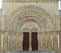
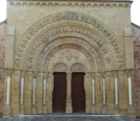
Morlaàs, Sainte-Foy
The Project
Home
Project description
Articles
Select a church
Select from list
Select from thumbs
Select from map
Selected church
Synopsis
Capitals
Map
Panoramas
Zooms
Photos
Archive
Documents
Models
Explore buildings
The Churches
Cost chart per decade
Relative cost map
Costs as heatmap
Explore Carvers
The Carvers
List of carver/modes
Articles
Contact
Contact
Building Data for Morlaàs,
Sainte-Foy
Type: Parish
Affiliation:
Region: Aquitaine
Department: Pyrénées-Atlantiques
Coords: 43.344, -0.263
Surveyed: 2013
Map
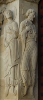
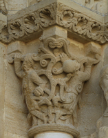
Zooms for Morlaàs,
Sainte-Foy
- created by Chris Henige during our many trips to northern France.
West - Left Jamb
West - Left Jamb
West - Left Jamb
West - Left Jamb
West - Right Jamb
West - Right Jamb
West - Right Jamb
West - Right Jamb
West - Tympanum
West - Tympanum
West Portal
West Portal
There are no Virtual Tour results for this building.